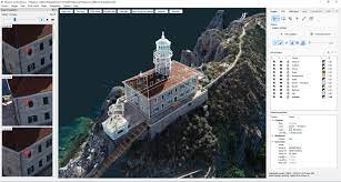
Photogrammetry software solution for land surveying professionals. 3D mapping & modelling. Fly a drone, generate point clouds, orthophotos, survey maps. We help people in the field do their job faster and easier. With real-life experience at the heart of our software, we help professionals do today what they couldn’t do yesterday. Our software is constantly evolving. What started as a tool created by surveyors, for surveyors, has turned into an agile solution that solves problems for many industries – from construction workers to first responder.
Opportunities are available to Basic, Advanced and Premium Subscribers only.