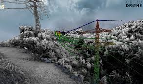
Orthodrone offers advanced, ultra-high-resolution spatial data acquisition and scientific analyses services for your industry or research needs. LiDAR, medium-format photogrammetry or multispectral surveys – with two hours of hover time, our multirotor systems accomplish the most challenging missions. Utilizing made-to-measure hybrid UAS with survey-grade sensors and in-house control solutions, we are your versatile and reliable partner for surveying and modelling in harsh environments.
Opportunities are available to Basic, Advanced and Premium Subscribers only.