
Remote Intelligence Solutions
Accountable Actions from Actionable Insights
Manage aerial and Field inspections with one solution that automates your Inspection Assessment and reporting workflows, providing greater efficiencies, accuracy, productivity, risk management, and compliance.
Remote Intelligence Solutions (RIS) provides comprehensive inspection, assessment, maintenance, and regulatory reporting management solutions.
Service Providers:
Extend your service capabilities by offering Remote Intelligence Solutions, an easy-to-use inspection management system.
Remote Intelligence Solutions (RIS) provides comprehensive inspection, assessment, maintenance, and regulatory reporting management solutions.
In near realtime, you and your client can manage Aerial and Field Inspections with one solution. Automated inspection assessment and reporting workflows provide greater efficiency, accuracy, productivity, risk management, and compliance.
In addition, Remote Intelligence Solutions helps Service Providers manage, schedule, and track their assets.
How it Works
RIS aggregates data from multiple sources and systems, manages inspection operations and assessment results in one place, assigns and tracks field and aerial inspections, and coordinates staff and vendor teams. RIS streamlines data collection, assessment, reporting, and tasking.
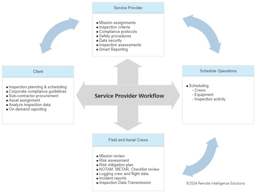
For example, an electrical utility company, one of our customers, creates a mission in our system containing the objects (poles) it wants to inspect and assigns it to the service provider. This mission contains the PO number, mission objectives, start and end dates, and other appropriate information. The customer uses the system to notify the service provider.
Preflight
The service provider assigns the crew and assets (aircraft, batteries, payloads) it will use.
To adhere to the customer’s compliance policy, the crew creates risk mitigation report(s), on-site emergency procedures, and a preflight checklist using the tools provided in the system.
Flight Planning
The crew selects which objects to inspect per flight from a map.
Using our mapping program, the crew can arrange these objects in flight order and upload the file to most ground control units.
Postflight
Once the flight is complete, the crew simply uploads the images into our software. The images are automatically processed, assigned to the parent structure, and batched into an inspection record containing the metadata from the parent.
In near real-time, you and/or the client can access the data and immediately apply hazard conditions that trigger accountable actions for those assigned to respond to that specific hazard.
In case of a mishap with the flight, the crew can generate an incident report provided via the system.
Reports / Flight Logs
Please Note: All report logs are customizable and filterable to meet your reporting requirements.
Example Reports:
Aircraft logs – number of flights, flight hours, maintenance schedules
Crew Logs – Number of flights, hours of flight, type of aircraft
Crew credentials –Aircraft certification(s), license renewal, physical renewal, availability
Transparency – Per field revision history
Enterprise – Aerial and Field Inspections:
Manage your Aerial and Field inspections in one solution to streamline data collection, assessment, reporting, and tasking.
Remote Intelligence Solutions automates your Aerial and Field inspection-assessment-reporting workflows to provide greater efficiencies, accuracy, productivity, risk management, and compliance.
Utility Solution Example Video
You are in control
Aerial inspections: Fly manned and unmanned aircraft to capture images of your structures. You upload these images, and the system will automatically create an inspection record containing all the metadata and assign images to that record.
Aerial Image Assessment: Our priority virtual assessment system drastically reduces the time it takes to review, annotate, assign conditions, and set in motion your SOP to respond. Instantly visualize these assessments using our Smart Reports and/or API this data to your existing solution.
Field inspections: From the object, inspectors create an inspection record, and the system automatically populates the record with metadata details. They fill out the object’s hazard conditions, take images and annotate them. Inspectors can open objects from GIS Systems, i.e., ESRI, Google Earth, or (or other systems).
Response Based on your SOPs: Based on the severity of the issue, task and alert people/groups to respond to issues that follow your protocol.
The Power
By pulling images and data together into one central solution, Remote Intelligence Solutions aggregates the management of aerial and underground inspections. No searching through filing cabinets, shared drives, Excel documents, or other storage devices. All your data is in one place with a complete history of who did what and when.
You can utilize the software you already own for discrete operations (mapping, ticketing, tasking, inventory, asset management), which become a part of a unified workflow. Absent these other systems, Remote Intelligence Solutions can deliver end-to-end inspection operations.
“Go live” in days, not months or years, with:
Streamlined aerial and field inspection-assessment-response workflows
Advanced condition assessment technology
Configurable Smart Reports
Bi-directional data exchange with third-party systems
Improve productivity by combining structured and unstructured data
Work smarter with Remote Intelligence Solutions